


Boucle La Clusaz Les Confins

dan69390
User
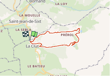

Length
14.4 km

Max alt
1443 m

Uphill gradient
584 m
Km-Effort
22 km

Min alt
1030 m

Downhill gradient
589 m
Boucle
Yes
Creation date :
2022-08-02 07:16:11.0
Updated on :
2022-08-02 13:49:30.209
5h57
Difficulty : Difficult

FREE GPS app for hiking
 SityTrail
IGN / Geographical institutes
SityTrail Plus
The world is yours!
About
Trail Walking of 14.4 km to be discovered at Auvergne-Rhône-Alpes, Upper Savoy, La Clusaz. This trail is proposed by dan69390.
Positioning
Country:
France
Region :
Auvergne-Rhône-Alpes
Department/Province :
Upper Savoy
Municipality :
La Clusaz
Location:
Unknown
Start:(Dec)
Start:(UTM)
299833 ; 5087123 (32T) N.
Comments